ECOSOLA examined the role of urban agriculture and urban ecosystems (‘green infrastructure’) in Dar es Salaam, Tanzania and the Western Cape Region, South Africa. The social and economic scientists in the research team investigated how urban and peri-urban agriculture affects the livelihoods of city dwellers, how urban farmers cope with legal, technical, financial and environmental challenges and which potentials urban agriculture holds for sustainable urban development. For further information concerning these issues you should check the ECOSOLA project website.
The ecological experts in the ECOSOLA team investigated the availability of ecosystem services in the peri-urban fringe of Dar es Salaam and developed planning tools for the integration of local ecosystems into future urban development. In the following the applied methods and results of the ecological ECOSOLA-workpackage will be outlined in more detail.
Study area
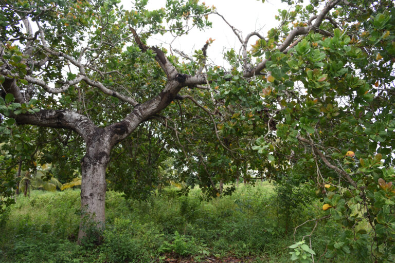
The study was conducted in the small village Vikawe (Kibaha District, Coast Region) located close to the north-western outskirts of Dar es Salaam. This rural area features farmland, pastures, uncultivated grass- and bushland as well as riparian forests along Mpiji River, which marks the border between Coast and Dar es Salaam Regions. In the light of the rapid growth and expansion of Dar es Salaam, an urbanization of the study area during the next 10-20 years can be projected.
Habitat mapping
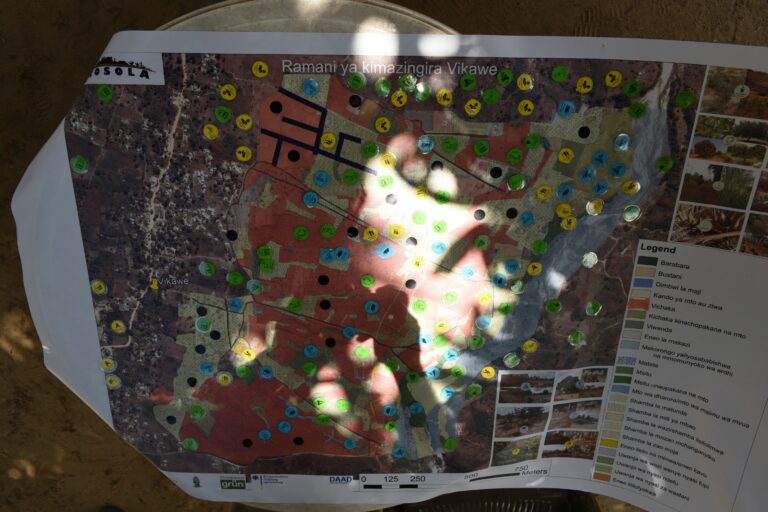
As a first step, based on the CORINE land cover classification of the European Environment Agency, a preliminary habitat classification key was drafted for Greater Dar es Salaam. In October/November 2017 this was then used to map the habitat types of the study area in the field. The resulting field maps were digitized and a map of the habitat types in Vikawe was prepared in a GIS. This map built the foundation for all following tasks.
Participatory mapping of ecosystem services
In March 2018 a workshop on land use and ecosystem services in Vikawe was arranged. Participants were invited by the local government of Vikawe and comprised local farmers, herders and sand miners, women and men, young and old villagers as well as newcomers and long-time residents. The major objective was to investigate which benefits Vikawe residents draw from local ecosystems.
To build a common knowledge base for all participants, at first the habitat map was presented, all relevant local habitat types were introduced and the concept of ecosystem services was outlined. The central task of the workshop was then to map the distribution of ecosystem services in the study area by the workshop participants (participatory mapping). Moreover, all participants completed questionnaires to assess how they rate the relevance of different ecosystem services for their livelihoods and how they rank the capacity of different habitat types for the provision of ecosystem services.
Preparation of an ecosystem service-based land use plan
Based on the habitat map and the map of ecosystem services an ecosystem service-based land use plan for the establishment of a new urban district in the study area was drafted. The draft plan involved measures to prevent erosion, flooding and other environmental hazards. Ecosystems with the potential to provide benefits for the future urban community were integrated in the plan as green infrastructure.
In September 2018 the draft plan was presented, discussed and revised in a second workshop in Vikawe. Most of the participants of the participatory mapping six months before joined this second workshop as well. Furthermore, the draft plan was submitted to the town planners of the Kibaha Municipal Council for revision. Finally, a model of the land use plan was built and presented in the Kibaha Municipal Council in September 2019.
Guidelines for ecosystem service-based land use planning
In order to share the outcomes of this study with planners, government officials, land developers and other interested readers, a guideline on ecosystem service-based land use planning in Tanzania was prepared. A PDF-copy of the guideline can be downloaded here.